THE ORIGIN OF THE NORFOLK BROADS
A CLASSIC CASE OF CONFIRMATION BIAS
BILL SAUNDERS
The Origin of the Norfolk Broads - a classic case of Confirmation Bias
mallards
The "transition" evidence.
"In addition, it should be possible to find cases in which the records throw light on the transition of a given piece of land from turbary to broad." Smith, 1960
Smith's basic purpose was to put some dates to the creation of the broads, and in so doing corroborate Joyce Lambert's revelation that the Norfolk Broads were not natural lakes but man-made. This he fully achieved in many different ways. For example, he sought and found conclusive evidence of changes in the description of specific tracts of land from 'turbary' to 'fishery' or 'waterground' and thence to 'broad', records which in themselves provide clear proof, independent of the geophysical evidence, that some broads are flooded peat diggings.
Smith always equates the word 'turbary' with a great, big pit which is completely free of water. Here is an example:
"The St. Benet's turbaries in Irstead, Barton and Neatishead, mentioned together in a lease of the late 13th century, are represented in a lease of the 16th century by the fisheries of Burntfen, Irstead Fen and Barton Fen, which were worth 39s. 8d. together with the fishery next to Wroxham bridge and the eelset on the river Thurne. In thirteenth century records, both these last fisheries are mentioned, but there is no sign of the first three. Again, one is left to presume that the valuable sixteenth century fisheries represented waters that covered the turbaries of the thirteenth". Smith, 1960
The actual facts, of course, raise no presumption that these turbaries in the thirteenth century were great big, dry pits, which only flooded subsequently. The evidence is consistent with that scenario, but it is equally consistent with small, exhausted sections in these turbaries being flooded in the thirteenth and earlier centuries, but not yet containing fish. It all depends on your point of view. Any presumption of the former rather than the latter stems solely from Smith's preconceptions.
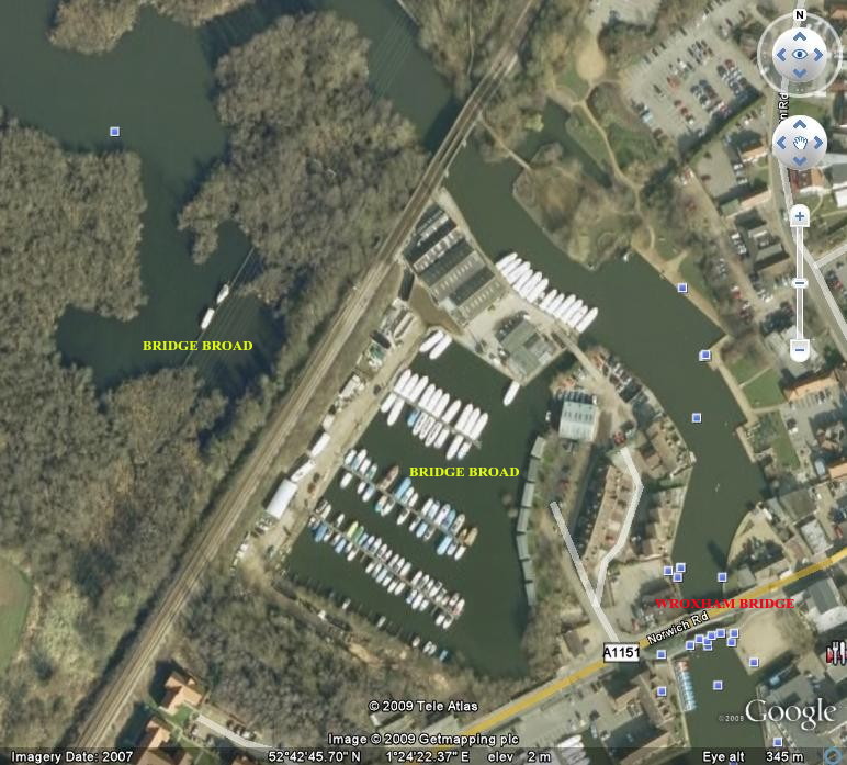
What one is left to do instead is to wonder where exactly this fishery was "next to Wroxham bridge", with records of it dating from the middle of the 13th century. A fishery was not at all the same thing as an eelset.
Bridge Broad, divided in the nineteenth century by the Norwich to Cromer railway line, is next to the present and historic site of a road bridge over the River Bure linking Wroxham and Hoveton.
Flooded turbaries were used as fisheries in the fourteenth, fifteenth and sixteenth centuries. Here surely is evidence which points straight at the same practice in the thirteenth century, a period when, for Smith, all the great peat pits were still completely dry.
Again, it does all rather depend on your point of view.
Smith notes several other examples of how the descriptions of identifiable tracts of land change in the records:
"There is in fact a long period of transition in the late fourteenth and fifteenth centuries when the usual way of describing the old turbaries changes first to "fen" (mora) and then in a few cases to "water and marsh" or "water and fen". One may suspect that these refer to land which was formerly described as turbary, but which had become partially flooded and unworkable, or workable only under difficulties.
It is possible that the changes in nomenclature from turbary to fen represented merely a change in the fashionable and customary term used to describe what were in fact the same realities on the ground, but it seems much more likely that it reflects a real change to wetter conditions on the ground in the old turbaries, and possibly in the flood plain as a whole." ibid.
Here is clear evidence of change, but again Smith's preconceptions influence his judgement about what is "much more likely" and what "one may suspect" to be the cause and nature of this change.
He imbues the words 'fen' and 'marsh' in this context with a meaning quite alien to their useage in medieval records. Neither was worthless, water-logged bog or swamp, both were valuable types of land, bought sold and leased for grazing or the production a variety of staple commodities.
The description of a piece of land usually changes because of a change in the use to which it is put, not because of what is "fashionable or customary". The records tell us that, from the second half of the fourteenth century, areas of the peat fen which had been allocated to turbary, but which were still wholly or partly intact, were designated for a different use. This was a period of great social and economic change, initiated by the catastrophe of the Black Death; the demand for peat fuel had dropped dramatically, and with it the requirement for large areas of fen to be reserved for turbary. Why should this particular change instead be attributed to a putative and unquantified rise in water levels? (See under "Why did they stop?").
Obviously conditions in the turbaries would have got wetter. The more peat that was extracted, the more water-filled holes there would be where none had existed before, hence the references to water in the "old" turbaries. Here is clear evidence that the peat diggings extended below the level of the water table in the fourteenth century. We know that they also extended below the level of the water table in the twelfth and thirteenth centuries. There is no evidence of any change having taken place in that respect.
If you dig up peat in a turbary from as great a depth as is practicable (as the makers of the broads are known to have done), you create a hole in the ground which no longer contains any peat. You cannot dig peat from the same spot twice. That hole in the ground ipso facto ceases to have any function or value as turbary; if it fills up with water because it extends below the water table, and is put to some other use such as a fishery, it is scarcely surprising if it is no longer described or valued as a turbary.
Smith saw it as part of his task to "establish the conditions under which the turf pits were abandoned". He was thus predisposed to the idea that they must have been abandoned because of a change in their physical environment, and his interpretation of the evidence is biased towards that conclusion.
The "transition" evidence proves that deep excavations within areas of peat fen which were allocated to turbary filled up with water, were used as fisheries, and were eventually described as broads.
- This proves that the broads are flooded peat diggings, but not when or why the flooding occurred.
back to: "The Historical Evidence in Detail" HOME
The Origin of the Norfolk Broads - a classic case of Confirmation Bias
mallards